M25 motorway
- "London Orbital" redirects here. For the book of this title, see Iain Sinclair.
|
|
|
|---|---|
| Route information | |
| Part of |
|
| Length: | 117 mi (188 km) |
| Existed: | 1975 – present |
| History: | Completed 1975-1986 |
| Major junctions | |
| Orbital around London | |
| From: | Hawley (near Dartford) (A2) |
J3 → M20 motorway J5 → M26 motorway J7 → M23 motorway J12 → M3 motorway J15 → M4 motorway J16 → M40 motorway J21 → M1 motorway J23 → A1(M) motorway J27 → M11 motorway |
|
| To: | West Thurrock (A13) |
| Location | |
| Primary destinations: |
London, Dartford, Sevenoaks, Reigate, Staines, Heathrow Airport |
| Road network | |
|
Roads in the United Kingdom |
|

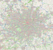
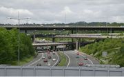
The M25 motorway, or London Orbital, is a 117-mile (188 km) orbital motorway that almost encircles Greater London in the United Kingdom. The motorway was first mooted early in the 20th century, a few sections, based on the now abandoned London Ringways plan, were constructed in the early 1970s and it was completed in 1986. The M25 is one of the world's longest orbital roads[1] and one of the busiest and most congested parts of the British motorway network. 196,000 vehicles were recorded in a single day near London Heathrow Airport. Plans to widen additional sections to eight lanes (four each way) were scaled back in 2009 in response to rising costs.[2]
Contents |
Description
Although originally built as a six-lane motorway (three in each direction), much of the motorway has been widened to eight lanes. There is a ten-lane section between junctions 12 and 14 and a twelve-lane section between junctions 14 and 15 (See map in Current Developments section).
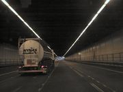
The M25 is not a continuous loop. To the east of London, the toll crossing of the Thames between Thurrock and Dartford is the lesser grade A282. The Dartford Crossing, which consists of two tunnels and the QE2 (Queen Elizabeth II) bridge, is named Canterbury Way. Passage across the bridge or through the tunnels is subject to a toll, depending on the kind of vehicle. Making this stretch a motorway would stop any traffic not permitted to use motorways from crossing the Thames east of the Woolwich Ferry.
At junction 5 near Sevenoaks, drivers continuing around the M25 in either direction must follow the slip roads. The anticlockwise carriageway continues eastward as the M26 (towards the M20); the clockwise carriageway continues towards the south coast as the A21.
The distance of the motorway from central London (taken as Charing Cross) varies from about 12 miles (19 km) near Potters Bar to 20 miles (32 km) near Byfleet. In some places (Enfield, Hillingdon and Havering) the Greater London boundary has been realigned to the M25 for minor stretches; while in others, most notably in Essex and Surrey, it is many miles distant. Major towns such as Epsom, Watford, and Loughton are within the M25. North Ockendon is the only settlement of Greater London situated outside the M25. In 2004, following an opinion poll, a move was mooted by the London Assembly to align the Greater London boundary with the M25.[3]
The three service areas are located in the central north (Junction 23 South Mimms), south east (Clacket Lane) and central east (Thurrock). A fourth, at Cobham, is due to open in 2012.[4]
Much of the M25 is lit to help reduce accidents. The current illuminated sections are from Dartford to junction 3, junctions 6 to 16, junctions 18 to 21A, and junctions 23 to 31. The type of lighting varies. Some sections use the older yellow low-pressure sodium (SOX) lighting while others use modern high-pressure sodium (SON) lighting. Some stretches have recently been upgraded to SON lighting. These include Junction 5, junctions around Heathrow and Junction 27.
The motorway passes through several policing areas. Junctions 1–5 are in Kent, 6–14 in Surrey (passing in places through Greater London and Berkshire), 15–16 are in Buckinghamshire, 17–24 are in Hertfordshire, 25 in Greater London (the Hertfordshire border going around the junction's northern edge), 26–28 in Essex, 29 in Greater London and 30–31 in Essex. Policing the road is carried out by an integrated policing group made up of the Metropolitan, Thames Valley, Essex, Kent, Hertfordshire and Surrey forces.
The M25 is one of Europe's busiest motorways. In 2003, 196,000 vehicles a day were recorded on the motorway near London Heathrow Airport between junctions 13 and 14.[5]
History
Plans and construction


The idea of an orbital road around London was first proposed early in the 20th century and was re-examined in Sir Charles Bressey's and Sir Edwin Lutyens' The Highway Development Survey, 1937 and Sir Patrick Abercrombie's County of London Plan, 1943 and Greater London Plan, 1944. Abercrombie's plan proposed a series of five roads encircling the capital.
A precursor of the M25 was the North Orbital Road (see A414 road).
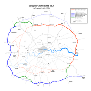
In the post-war years little was done to implement Abercrombie's plans but in the 1960s the Greater London Council developed an ambitious plan, the London Ringways plan, for a network of ring roads around the capital. This plan was hugely controversial due to the destruction required for the inner two ring roads and the enormous anticipated cost. The plan was modified a number of times to overcome opposition from the residents of threatened areas and the government, but was cancelled in 1973. Parts of the two outer ring roads, Ringways 3 and 4, were begun in 1973 and became the first two sections of the M25 to open in 1975 (junction 23 to junction 24) and 1976 (junction 6 to junction 8).The M16 motorway was the designation planned in the late 1960s and early 1970s for use on Ringway 3, a new motorway planned as part of the London Ringways Plan to run a circular route around London.
Construction of the first section of the M16 began in 1973 between South Mimms and Potters Bar in Hertfordshire and opened in September 1975 with the temporary general purpose road designation A1178. During construction of the first section of the motorway, the majority of the Ringways plan was cancelled and, in 1975 the plans for Ringway 3 were modified to combine it with parts of another motorway, Ringway 4, the outermost Ringway.
The M16 designation was dropped and the combined motorway was given the designation M25 which had originally been intended for the southern and western part of Ringway 4. The section of Ringway 3 west of South Mimms anti-clockwise around London to Swanley in Kent was cancelled and the section clockwise from Potters Bar to the Dartford Tunnel was constructed between 1979 and 1982. The section of Ringway 3 south of the river between Dartford and Swanley was constructed between 1974 and 1977.
Construction of the M25 continued in stages until its completion in 1986. The stages were not constructed contiguously but in small sections, such as Dartford to Swanley (junction 1 to junction 3) and Potters Bar to Enfield Town (junction 24 to junction 25). As the orbital road developed the sections were linked. Each section was presented to planning authorities in its own right and was individually justified, with almost 40 public inquiries relating to sections of the route. Maps at this time depicting these short sections named the route as the M16 but this changed before completion. The northern sections of the M25 follow a similar route to the World War II Outer London Defence Ring.
Prime Minister Margaret Thatcher officially opened the M25 on 29 October 1986, with a ceremony in the section between J22 and J23 (London Colney and South Mimms). The initial tenders for the construction of the M25 totalled £631.9 million. This did not include compulsory purchase of land and subsequent upgrades and repairs.
Operational history
Soon after the motorway opened in 1986 traffic levels exceeded maximum designed capacity and in 1990 the Secretary of State for Transport announced plans to widen the whole of the M25 to four lanes.[6] By 1993 the motorway that was designed for a maximum of 88,000 vehicles per day was carrying 200,000,[7] 15% of UK motorway traffic volume was on the M25 and there were plans to add 6 lanes to the section from Junction 12 to 15 as well widening the rest of the motorway to 4 lanes[8]
In 1995 a contract was awarded to widen the section between junctions 8 and 10 from six to eight lanes for a cost of £93.4 million[9] and a Motorway Incident Detection and Automatic Signalling (MIDAS) system was introduced to the M25 from junction 10 to junction 15 at a cost of £13.5m in 1995 and then extended to junction 16 at a cost of £11.7m in 2002. This consists of a distributed network of traffic and weather sensors, speed cameras and variable-speed signs that control traffic speeds with little human supervision, and has improved traffic flow slightly, and reduced the amount of start-stop driving.[10]
In 1995 there was a proposal to widen the section close to Heathrow Airport to 14 lanes. This attracted fierce opposition from road protesters opposing the Newbury Bypass and other schemes[11] and it was cancelled shortly afterwards.[12] However, in 1997 the Department of Transport announced new proposals to widen the section from junction 12 (M3) and junction 15 (M4) to 12 lanes. At the Terminal Five public inquiry a Highways Agency official said that the widening was needed to accommodate traffic to the proposed new terminal, however the transport minister said that no such evidence had been given.[13] Environmental groups objected to the decision to go ahead a scheme that would create the widest motorways in the UK without holding a public inquiry.[14] The decision was again deferred. A decision to go-ahead was given for a 10-lane scheme in 1998[15] and was finally opened in 2005 with ten lanes from junctions 12 to 14 and twelve lanes from 14 to 15.[16]
In 2007 capacity at junction 25 (A10/Waltham Cross) was increased and the Holmsdale Tunnel was widened to 3 lanes in a eastern direction at a cost of £75 million.[17]
Work to widen the exit slip-roads in both directions at Junction 28 (A12 road/A1023) was completed in 2008. It was designed to reduce the amount of traffic queueing on the slip roads at busy periods, particularly traffic from the clockwise M25 joining the northbound A12 where the queue can extend onto the inside lane of the Motorway.[18]
Design, Build, Finance and Operate' (DBFO) contract
In 2006 the Highways Agency proposed to widen 63 miles (101 km) of M25 from six to eight lanes, between junctions 5-6 and 16-30 as part of a Design, Build, Finance and Operate (DBFO) project.[19] A shortlist of contractors was announced in October 2006 for the project which was expected to cost £4.5 billion.[20] Contractors were asked to resubmit their bids in January 2008[21] and in June 2009 the new transport minister indicated that the cost had risen to £5.5 billion and the benefit to cost ratio had dropped considerably.[22] In January 2009 the government announced that plans to widen the sections from Junction 5-7 and from 23-27 had been 'scrapped' and that Hard shoulder running would be introduced instead.[23]
In 2009 a £6.2 billion M25 'Design, Build, Finance and Operate' (DBFO) Private finance initiative contract[24] was awarded to Connect Plus to widen the sections between junctions 16 and 23 and between junctions 27 and 30 and maintain the M25 and the Dartford Crossing for a 30 year period. Two further sections, between Junctions 23 and 27 and between junctions 5 and 7, are included as 'options' within the DBFO contract.[25]
Current developments
M25 Jct 16 to 23 Widening
Works on widening the motorway between junctions 16 and 23 (M40-A1(M))[26] started in July 2009 at an estimated cost of £580m.[27] It is intended that work between junctions 16 and 18 will be completed by summer 2010, between junctions 18 and 21 by summer 2011, and the final stretch between junctions 21 and 23 by summer 2012.[28]
M25 Jct 27 to 30 Widening
Widening between junctions 27 to 28 (M11-A12 Brook Street) started in July 2009[29] with the rest of the work following in 2010 and 2011.[30]
Proposed developments
M25 Jct 5 to 7 Widening
The Highways Agency plans to introduce hard shoulder running on the M25 from Junctions 5 to 7 (M26 – M23/Redhill)[31] with work starting after the London Olympics in 2013, opening in 2016.[32]
M25 Jct 23 to 27 Widening
The Highways Agency plans to introduce hard shoulder running on the M25 from Junctions 23 to 27 (A1(M)-M11)[33] with work starting after the London Olympics in 2013, opening in 2016.[34]
Junction 30 improvement
In 2007 as part of the Thames Gateway Delivery Plan plans were announced to increase capacity at Junction 30 (Thurrock). Following a review by the Highways Agency an announcement on the recommended scheme is expected by the end of 2008. An early estimate on the start of major works is given for 2013/2014.[35]
Lower Thames Crossing
In 2009 the Department for Transport published options for a new Lower Thames Crossing to add capacity to the Dartford Crossing or create a new road and crossing linking to the M2 and M20 motorways.[36]
Comparisons
Other cities encircled by motorways include Manchester using the M60 motorway, Birmingham using parts of the M5, M6 and M42 and from 2011 Glasgow will have an orbital motorway made of the M8, M73 and M74 although one section of the route passes through the centre of the city.[37]
The M25 is the second-longest ring road in Europe, after the Berlin Ring (A 10) which is 5 miles (8.0 km) longer.
The M25 is one of the busiest motorways in Europe:-
- M25 around London: 196,000 vehicles a day recorded in 2003 between junctions 13 and 14 near London Heathrow Airport,[5].
- A23 (near Vienna): More than 200,000 vehicles on an average day.(de:Autobahn Südosttangente Wien)
- A 100 (near Berlin): 216,000 vehicles in a day was recorded in 1998(de:Bundesautobahn 100)
- A4 motorway (near Paris): 257,000 vehicles a day recorded in 2002 ([1])).
Popular culture
The M25 (including the A282 Dartford Crossing) is known for its frequent traffic jams. These have been the subject of so much comment from such an early stage that even at the official opening ceremony Margaret Thatcher complained about "those who carp and criticise". The jams have inspired jokes ("the world's biggest car park", "the London Orbital Car Park"), songs (Chris Rea's "The Road to Hell")[38] and the following theory:
Many phenomena – wars, plagues, sudden audits – have been advanced as evidence for the hidden hand of Satan in the affairs of Man, but whenever students of demonology get together the M25 London orbital motorway is generally agreed to be among the top contenders for Exhibit A.—from Good Omens, by Terry Pratchett and Neil Gaiman.
The M25 was also mentioned in the popular British sketch comedy show, A Bit of Fry and Laurie, starring Stephen Fry and Hugh Laurie. In a sketch featuring Dominic Appleguard, the title character, played by Fry, is shown to be mentally different. After stating, "you can always trust him with a peony and a cod", and showing Stephen Fry holding a cod over two large red peonies and rocking it in his arms like a baby, Hugh Laurie's voice over continues, "Dominic Appleguard designed the M25."
The road enjoyed a more positive reputation among ravers in the late 1980s as the then new Orbital Motorway was a popular route to the parties that took place around the outskirts of London. The use of the M25 for these raves inspired the name of electronic duo Orbital.
Racing

The orbital nature of the motorway, in common with racetracks, lent itself to unofficial, and illegal, motor racing. At the end of the 1980s, before the advent of speed enforcement devices, owners of supercars, many employed in the financial service industry in the City and in Docklands, would meet at night at service stations such as South Mimms and conduct time trials. Times below 1 hour were achieved; an average speed of over 117 mph (188 km/h), which included coming to a halt at the Dartford Tunnel toll payment booths.[39][40]
Junctions
Data[41] from driver location signs provide carriageway identifier information. The numbers on the signs are kilometres from a point near the River Thames, east of London, when travelling clockwise on the motorway. The table below gives details of each junction, including the roads interchanged and the destinations that are signed from the motorway. Figures in kilometres are from the driver location signs; figures in miles are derived from them.
| M25 Motorway | ||||
| mi | km | Clockwise exits (A Carriageway) | Junction | Anti-clockwise exits (B Carriageway) |
| Dartford Crossing A282 Dartford Tunnel |
River | Dartford Crossing A282 Queen Elizabeth Bridge' |
||
| 3.5 | 5.7 | Erith A206 | J1a | Swanscombe A206 |
| 4.7 | 7.5 | Dartford A225 | J1b | No Exit |
| 5.5 | 8.8 | London (South East), Canterbury A2, (M2), Bluewater Dartford (A225) |
J2 | London (South East), Canterbury A2, (M2), Bluewater |
| 8.7 | 14.0 | London (South East) A20 Maidstone M20 Swanley B2173 |
J3 | Maidstone, Channel Tunnel, Folkestone, Dover M20 London (South East), Swanley A20 |
| 12.2 | 19.6 | Bromley A21 Orpington A224 |
J4 | Bromley A21 Orpington A224 |
| 16.3 | 26.2 – 26.4 | Sevenoaks, Royal Tunbridge Wells, Hastings A21 | J5 | Maidstone, Channel Tunnel, Folkestone, Dover M26 (M20) Sevenoaks, Royal Tunbridge Wells A21 |
| 21.0 | 33.8 | Clacket Lane services | Services | Clacket Lane services |
| 25.8 | 41.6 | East Grinstead, Eastbourne, Caterham, Godstone A22 Westerham (A25) |
J6 | East Grinstead, Eastbourne, Caterham, Godstone, A22 Redhill (A25) |
| 28.6 | 46.0 | Gatwick Airport, Crawley, Brighton, East Grinstead, Croydon M23 | J7 | Gatwick Airport, Crawley, Brighton, Croydon M23 |
| 31.9 | 51.4 | Reigate, Sutton A217 Redhill (A25) |
J8 | Reigate, Sutton A217 Kingston (A240) |
| 38.5 | 62.0 | Leatherhead A243 Worthing (A24) |
J9 | Leatherhead A243 Worthing (A24) |
| 39.5 | 63.5 | Cobham Services (Scheduled opening 2012)[4] |
Services | Cobham Services |
| 45.0 | 72.4 | London (South West), Sutton, Guildford, Portsmouth A3 | J10 | London (South West), Guildford, Portsmouth, A3 |
| 49.8 | 80.2 | Chertsey A317 Woking A320 |
J11 | Woking A320 Chertsey A317 |
| 52.1 | 83.8 | Basingstoke, Southampton, Richmond M3 | J12 | Basingstoke, Southampton, Richmond M3 |
| 55.2 | 88.8 | Staines A30 | J13 | London (West), Staines, Windsor A30 |
| 57.0 | 91.8 | Heathrow Airport (Terminals 4, 5 and Cargo) A3113 dedicated spur | J14 | Heathrow Airport (Terminals 4, 5 and Cargo) A3113 dedicated spur |
| 59.0 | 95.0 | The WEST, Slough, Reading, London (West), Heathrow Airport (Terminals 1, 2 and 3) M4 | J15 | The WEST, Slough, Reading, London (West), Heathrow Airport (Terminals 1 2, and 3) M4 |
| 63.8 | 102.6 | Birmingham, Oxford, Uxbridge, London (West) M40 | J16 | Birmingham, Oxford, Uxbridge, London (West) M40 |
| 68.7 | 110.5 | Maple Cross (A412) | J17 | Maple Cross, Rickmansworth (A412) |
| 69.9 | 112.5 | Rickmansworth, Chorleywood, Amersham A404 | J18 | Chorleywood, Amersham A404 |
| Watford A41 | J19 | No Exit | ||
| 73.8 | 118.7 | Hemel Hempstead, Aylesbury A41 | J20 | Hemel Hempstead, Aylesbury A41 A4251 |
| 76.3 | 122.8 | The NORTH, Luton & Airport M1 | J21 | The NORTH, Luton & Airport M1 |
| 76.9 | 123.7 | Watford A405 Harrow (M1 South) |
J21A | St Albans A405 London (North West) (M1 (South)) |
| 80.6 | 129.7 | St Albans A1081 | J22 | St Albans A1081 |
| 83.3 | 134.0 | Hatfield A1(M) London (North West) A1 Barnet A1081 South Mimms services |
J23 Services |
Hatfield A1(M) London (North West) A1 Barnet A1081 South Mimms Services |
| 85.9 | 138.2 | Potters Bar A111 | J24 | Potters Bar A111 |
| 91.4 | 147.1 | Enfield Town, Hertford A10 | J25 | Enfield, Hertford A10 |
| 94.9 | 152.7 | Waltham Abbey, Loughton A121 | J26 | Waltham Abbey, Loughton A121 |
| 99.2 | 159.7 | London (North East), Stansted Airport, Harlow, Cambridge M11 | J27 | London (North East), Stansted Airport, Harlow, Cambridge M11 |
| 107.1 | 172.4 | Chelmsford, Witham, Colchester A12 Brentwood A1023 |
J28 | Chelmsford, Romford A12 Brentwood A1023 |
| 109.9 | 176.8 | Romford, Basildon, Southend A127 | J29 | Basildon, Southend A127 |
| 115.2 | 185.4 | Thurrock (Lakeside), Tilbury A13 Thurrock services |
J30 Services |
Dagenham, Thurrock (Lakeside), Tilbury A13, (A1306, A126, A1090) Thurrock Services |
| 115.9 | 186.6 | No exit | J31 | South Ockendon, Dagenham A1306 |
| Dartford Crossing A282 Dartford Tunnel |
River | Dartford Crossing A282 Queen Elizabeth Bridge' |
||
References
- ↑ "M25 London Orbital Motorway (Junctions 13 to 30)". The Motorway Archive. http://www.iht.org/motorway/m25j13j30.htm. Retrieved 3 January 2009.
- ↑ Webster, Ben (2009-06-25). "Rising costs put the brakes on dozens of roadbuilding projects". The Times (London). http://business.timesonline.co.uk/tol/business/industry_sectors/transport/article6571879.ece. Retrieved 2010-05-12.
- ↑ Any such move would be bound to be resisted by the communities affected, including such major towns as Watford, Loughton and Epsom.London Assembly - Poll says M25 is London's "natural boundary". 2 March 2004.
- ↑ 4.0 4.1 "M25 MSA New Barn Farm Cobham". Highways Agency. http://www.highways.gov.uk/roads/projects/26511.aspx. Retrieved 2010-08-14.
- ↑ 5.0 5.1 "Motorway traffic up 4% on 2003". BBC News. 12 August 2004. http://news.bbc.co.uk/2/hi/uk_news/3558822.stm. Retrieved 3 January 2009.
- ↑ "HANSARD 3 December 1990 Written Answers (Commons) TRANSPORT". http://hansard.millbanksystems.com/written_answers/1990/dec/03/m25.
- ↑ "The bluffer's briefing on: The M25". The Independent (London). 1993-03-24. http://www.independent.co.uk/news/uk/the-bluffers-briefing-on-the-m25-1499570.html. Retrieved 2010-05-12.
- ↑ "M25 (Widening)". Hansard. http://hansard.millbanksystems.com/commons/1993/feb/18/m25-widening.
- ↑ "M25 scoop for Balfour in Surrey". http://www.cnplus.co.uk/news/m25-scoop-for-balfour-in-surrey/955396.article.
- ↑ "Case Study - M25 Controlled Motorway". Highways Agency. http://www.dft.gov.uk/itstoolkit/CaseStudies/m25-controlled-motorway.htm.
- ↑ Wolmar, Christian (1995-04-04). "The roadblock that became a bandwagon". The Independent (London). http://www.independent.co.uk/news/uk/the-roadblock-that-became-a-bandwagon-1614137.html. Retrieved 2010-05-12.
- ↑ Cohen, Nick (1995-04-02). "Pointless lies that reveal so much". The Independent (London). http://www.independent.co.uk/opinion/pointless-lies-that-reveal-so-much-1613955.html. Retrieved 2010-05-12.
- ↑ Wolmar, Christian (1997-03-21). "Minister gives green light to widen M25". The Independent (London). http://www.independent.co.uk/news/minister-gives-green-light-to-widen-m25-1274054.html. Retrieved 2010-05-12.
- ↑ "Plans to widen M25 to 12 lanes under attack". http://www.getsurrey.co.uk/news/s/80175_plans_to_widen_m25_to_12_lanes_under_attack.
- ↑ "BAA makes plans for Terminal 5 despite inquiry". http://www.nce.co.uk/baa-makes-plans-for-terminal-5-despite-inquiry/845174.article.
- ↑ "M25 Jct 12 to 15 Widening". Highways Agency. http://www.highways.gov.uk/roads/projects/4084.aspx.
- ↑ "£75 MILLION REFURBISHMENT FOR M25 HOLMESDALE TUNNEL AND JUNCTION 25 IMPROVEMENT WORK STARTS ON SATURDAY 6 May". Highways Agency. http://www.highways.gov.uk/news/pressrelease.aspx?pressreleaseid=132377.
- ↑ "M25 Junction 28 / A12 / Brook Street Interchange". Highways Agency. http://www.highways.gov.uk/roads/projects/3520.aspx.
- ↑ "Prequalification Document". Highways Agency. http://www.highways.gov.uk/roads/7717.aspx. Retrieved 2008-01-20.
- ↑ "Highways Agency announces shortlist for £4.5bn M25 DBFO". Contract Journal. http://www.contractjournal.com/Articles/2006/10/13/52504/highways-agency-announces-shortlist-for-4.5bn-m25-dbfo.html. Retrieved 2008-01-20.
- ↑ Andrea Klettner (2008-01-16). "Highways Agency calls for M25 widening bids to be resubmitted". Construction Journal. http://www.cnplus.co.uk/News/2008/01/highways_agency_calls_for_m25_widening_bids_to_be_resubmitted.html. Retrieved 2008-01-20.
- ↑ "Cost escalation hits M25 widening benefit to cost ratios". http://www.nce.co.uk/major-projects/m25-widening/cost-escalation-hits-m25-widening-benefit-to-cost-ratios/5203578.article.
- ↑ Helm, Toby (2009-01-18). "Ministers scrap plan to widen motorways". The Guardian (London). http://www.guardian.co.uk/politics/2009/jan/18/motorways-geoff-hoon. Retrieved 2010-05-12.
- ↑ Webster, Ben (2009-05-20). "PFI deal for M25 agreed despite price rise". The Times (London). http://business.timesonline.co.uk/tol/business/industry_sectors/transport/article6322870.ece. Retrieved 2010-05-12.
- ↑ "£6.2 billion M25 Design, Build, Finance and Operate (DBFO) contract awarded". Highways Agency. http://www.highways.gov.uk/news/pressrelease.aspx?pressreleaseid=174136.
- ↑ "M25 Jct 16 to 23 Widening". http://www.highways.gov.uk/roads/projects/5747.aspx.
- ↑ "M25 widening to four lanes begins". BBC News. 2009-07-08. http://news.bbc.co.uk/1/hi/england/8139940.stm. Retrieved 2010-05-12.
- ↑ "Highways Agency Timetable".
- ↑ "Weekly Summary of Roadworks in M25 Sphere - 30/09/2009". http://www.fleetdirectory.co.uk/fleet-news/index.php/2009/09/30/weekly-summary-of-roadworks-in-m25-sphere-30092009/.
- ↑ "M25 Jct 27 to 30 Widening". http://www.highways.gov.uk/roads/projects/5739.aspx.
- ↑ "M25 Jct 5 to 7 Widening". http://www.highways.gov.uk/roads/projects/5735.aspx.
- ↑ "Timetable". http://www.highways.gov.uk/roads/projects/13832.aspx.
- ↑ "M25 Jct 23 to 27 Widening". http://www.highways.gov.uk/roads/projects/5743.aspx.
- ↑ "Timetable". http://www.highways.gov.uk/roads/projects/13842.aspx.
- ↑ "The Thames Gateway Delivery Plan". Communities and Local Government. http://www.communities.gov.uk/documents/thamesgateway/pdf/565039.pdf. Retrieved 2008-11-25.
- ↑ "Dartford River Crossing Study into Capacity Requirement". Department for Transport. 2009-04-20. http://www.dft.gov.uk/about/strategy/capacityrequirements/dartfordrivercrossing/chap1execsummary.pdf. Retrieved 2009-04-26.
- ↑ http://www.transportscotland.gov.uk/projects/m74-completion/the-project Transport Scotland - M74 Completion Project - Retrieved 2009-09-06
- ↑ "Chris Rea interviewed by Will Hodgkinson, The Guardian, Friday 13 September 2002". London. 2002-09-13. http://arts.guardian.co.uk/fridayreview/story/0,,790672,00.html. Retrieved 2009-01-31.
- ↑ May, James (20 October 2007). "Speed, Greed And The M25". BBC Radio 4. http://www.bbc.co.uk/radio4/factual/pip/ap895/?focuswin.
- ↑ BBC Press Office. "Programme Information – Network Radio Week 43". Press release. http://www.bbc.co.uk/pressoffice/proginfo/radio/wk43/sat.shtml.
- ↑ "M25 Road Network Driver Location Signs". Highways Agency. http://www.highways.gov.uk/business/documents/070921-Final_DLS_map.pdf. Retrieved 2009-06-09.
Further reading
- Sinclair, Iain (2002), London Orbital: A Walk Around the M25, London: Granta Books, ISBN 1862075476.
- Phippen, Roy (2005), Travelling M25 Clockwise, London: Pallas Athene, ISBN 1873429908.
- Pratchett, Terry; Gaiman, Neil (2006), Good Omens, New York: William Morrow, pp. 13–14, ISBN 0060853964.
External links
- Highways Agency – Roadworks
- Highways Agency – Current Traffic Information
- Highways Agency – Dartford – Thurrock River Crossing
- The Motorway Archive's M25 page
- CBRD M25 Motorway Database
- CBRD M25 Opening Booklet
|
||||||||||||||||||||||||||||
|
|||||||||||||||||||||||||||||||||||||||||||||||||||||||||||||||||||||||||||

|
|||||||||||||||||||||||||